
The East Jutland Motorway, Skanderborg-Århus
DOI:
https://doi.org/10.7146/kuml.v25i25.106630Keywords:
east-jutland motorway, archaeology, skanderborg-århus, artifactsAbstract
The East-Jutland Motorway, Skanderborg-Århus.
During 1973-1975 the staff of Forhistorisk Museum, Moesgård, have untertaken archaeological investigations of the new motorway (Østjyske Motorvej) between Skanderborg and Århus. 41 archaeological sites have been located on this 22 km long stretch.
The work proceeded in the following fashion: Before roadwork started,
a 1) Careful examination of maps supplied by the Road Office in the scales 1:20,000, 1:4,000 and 1:1,000.
a 2) Examination of the National Museum's relevant parish surveys. All information received by the National Museum during the last century was transferred to the Road Office maps.
a 3) Examination of the collections and records of the two museums affected -Skanderborg Museum and Forhistorisk Museum.
a 4) Examination of aerial photographs, but to only a limited extent.
a 5) Thorough perambulation of the affected area, in the spring and autumn of 1973 and the spring of 1974. Most localities not already known from the parish surveys were discovered by this procedure. Of the 41 known localities with archaeological remains, 22 are on the road itself and the remaining 19 adjacent to it, without being directly affected.
a 6) Those localities where reconnaissance had yielded promising surface finds were subjected to trial excavation, to ascertain whether a total investigation was warranted.
a 7) Total excavation of 11 sites; 3 were not directly affected by the road, and the remaining 8 were.
During the actual work on the road, there was
b 1) Continual check on the work, to see whether other archaeological finds emerged. This work was to no avail, however, since the large earth-movers leave such uneven surfaces that nothing can be seen.
b 2) In some cases we were contacted by road gangs who suspected remains, which we investigated immediately, in order that work should not be delayed.
Simultaneously with this work, there was
c 1) Museum treatment of the finds, which are now found either at Forhistorisk Museum (FHM) or the National Museum (NM I). In the accompanying list of finds the case number reveals where the find is lodged.
Now the motorway has been largely completed, we can
d 1) Publish the finds. That is the purpose of this article, which, however, merely presents the artefacts themselves.
d 2) Exhibit the finds. Some objects have been presented in a special exhibition at Forhistorisk Museum in the autumn of 1973 and some in the permanent exhibition of the same museum (grave FK from Stilling Trehøje I (locality no. 19)).
d 3) Investigate at some stage barrows found close to the road. The investigated material does not include barrows from the Stone and Bronze Ages, but this is due to a mischance, since they are found in the vicinity. In order to obtain a more representative picture it is desirable to investigate these later.
Summary of finds
Stone Age: A total of 10 localities with Stone Age finds are known from the road. One of these is a presumptive cairn, which has not been investigated, since it is not touched by the road. 3 sites yielded single finds of stone axes and 6 must be settlements. Only two of these can be dated accurately. One (no. 15) contained material from the Mesolithic and the other (no. 19) material from the oldest phase of the Neolithic. The latter find was a settlement pit with more than 300 sherds which can be referred to at least 26 pots, 8 of which are decorated. The sherd material suggests a dating to Early Neolithic A/B.
Bronze Age: No finds could be referred with certainty to this period. This is no doubt fortuitous, however, as presumptive Bronze Age barrows are found near the road.
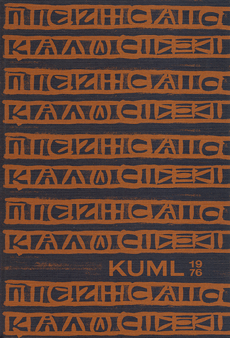
Iron Age: No less than 20 localities can be referred to this period. 4 of these are barrows, two of which have been investigated in connection with the road, while two have been investigated previously. Three or four mounds are situated in a group called Stilling Trehøje (finds no. 19-21). These are referred to the transition Late Roman to Early Germanic Iron Age, around 400 A.D. The three tumuli were roughly equal in size with a diameter of about 20 m and a preserved height of about 1 m. Centrally and towards the eastern periphery of the mounds was a fire layer resting on the original surface. This layer measured 4x6 m and was a few cm thick. It contained the cremated bones of the dead. In one mound, Stilling Trehøje I (find no. 19), there were in addition to the bones bear claws, which suggest that the corpse was wrapped in a bear skin. In addition the remains were found of two handled vessels which had also been burnt, of a three-layered comb and of two small bronze fittings, probably strap-holders. In the southern periphery of this mound were two urn graves (FH and FK). Grave FH was a black, finely burnished decorated pot with a tiny fragment of a three-layered comb. Urn grave FK contained, besides the burnt bones of an adult and some bear claws, a whole glass beaker with cut ornament and a Greek inscription "ΠIE ZHCAIC KAΛΩC", which translated reads 'Drink, and you will live well'; there were also 36 gamesmen of bone. The glass is probaly of south-eastern origin, most likely from the Black Sea, where it must have been produced in the 4th Century. The second mound which was excavated, Stilling Trehøje II (find no. 20), had in the cremation layer the remains of at least 4 pots, besides a flat spur of iron and a belt mount of bronze.
In addition to these burial mounds there are also a couple of moundless grave sites, namely the above-mentioned urns in the periphery of Stilling Trehøje I (find nr. 19) and an old find with two Roman Iron Age graves (find no. 40).
11 localities yielded settlement remains and three of these have been inhabited during more than one period of the Iron Age. Excavations have been carried out at five sites. These sites do not seem to conform to any topographic pattern, although no finds from the Roman Iron Age are known from sandy soil. It should be remarked in this connection, however, that most of the road runs across sticky clay soil so the settlement pattern is rather one-sided. Settlement remains from all periods of the Iron Age are found, though mostly from the Early Iron Age. A couple of localities are best interpreted as votive sites; both are situated in Illerup Ådal, including the famous weapon offering site.
The catalogue of finds p. 212 gives the location of the sites (from south to north) and a description of their contents.
Niels H. Andersen
Downloads
Published
How to Cite
Issue
Section
License
Fra og med årgang 2022 er artikler udgivet i Kuml med en licens fra Creative Commons (CC BY-NC-SA 4.0).
Alle tidligere årgange af tidsskriftet er ikke udgivet med en licens fra Creative Commons.
